Travel Advisory
August 10, 2023 - Southwestern Colorado - Southwest Colorado pass known to be treacherous — even in the summer

CDOT advierte a los camioneros: Tenga cuidado con el Paso US 160 Wolf Creek Pass en español
Southwest Colorado— Dryer roads and mild weather can mean safer driving conditions for most motorists. However, when traveling through Colorado’s mountains, semi-truck drivers can encounter challenging and dangerous conditions regardless of the weather. The Colorado Department of Transportation is warning big rig drivers to use extreme caution when traveling over mountain passes, like US Highway 160 Wolf Creek located in the southwest region of the state.
“This time of year, the weather is an unlikely factor in big-rig accidents. Instead, we are seeing loss of brakes or control on the steep downgrades of mountain passes,” said Colorado State Patrol Capt. John Trentini. “From 2015 to 2021, there have been 54 semi-truck crashes on the west side of Wolf Creek Pass. Three of those crashes resulted in needless fatalities.”
Additionally, a majority of the crashes occurred at the switchback curve located near the Wolf Creek scenic lookout area.
“Even with much of this pass being three and four lanes wide and having ample shoulders, it is necessary to maintain control by keeping low speeds and staying in lower gears,” added Kenneth Quintana, CDOT Maintenance Superintendent. “These road features can be deceiving, and many drivers find themselves out-of-control once they’ve made it halfway down the pass.”
In 2018, CDOT performed several safety improvements on US 160 over Wolf Creek Pass which included upgraded safety barriers, signage and striping.
“As CDOT continues to improve the highway safety features along this mountain corridor, we urge drivers to make sure they are doing their part to practice safe driving behaviors,” emphasized Quintana. “Knowledge and understanding of the road is extremely important when traversing over mountain passes, especially one like Wolf Creek Pass.”
CDOT urges all roadway users, especially commercial truck drivers to take time to familiarize themselves with their route.

Wolf Creek Pass
What is the speed limit? The posted speed limit for traffic traveling westbound, downhill from the summit varies from 25 to 45 MPH. Commercial trucks must maintain the lower 25 MPH speed.
What is the grade of the pass? The west side of the pass is at a 7% downhill grade.
What is the distance from the summit to the west base? The distance from the summit (near Wolf Creek Ski Area) to the west base of the pass (near Treasure Falls) is just over eight miles.
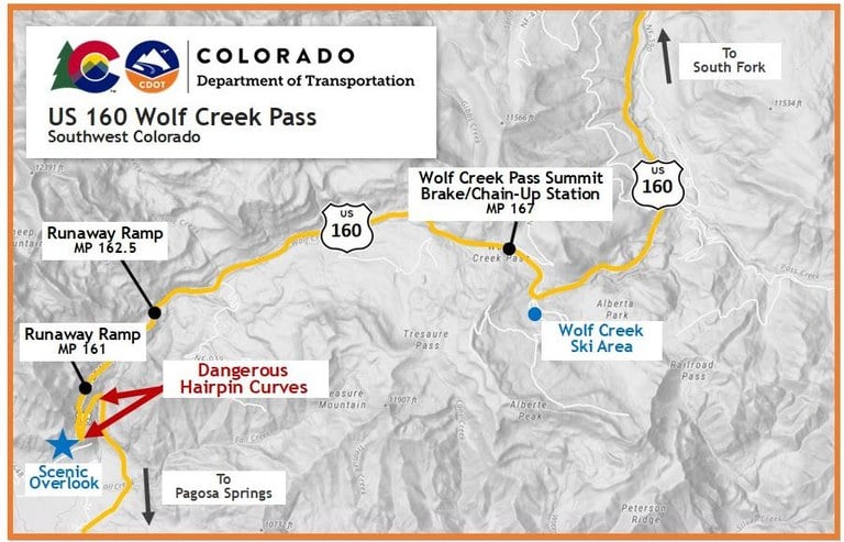
What curves will drivers encounter? A dangerous hairpin curve is located six and a half miles from the summit of Wolf Creek Pass.
Are there public access areas on the pass route? A ski area, forest roads and a public scenic lookout are all points of access along US 160 Wolf Creek Pass in which truckers may encounter other vehicles attempting to enter or exit the roadway.
Where are brake stations, chain-up stations and runaway ramps located?
- Truck drivers should inspect their brakes at the summit, before descending the eight mile trip down the pass. A wide shoulder area is available to all motorists traveling both west and eastbound. This area can also be used as a chain-up station
- Two runaway escape ramps are available for out-of-control trucks at mile points (MP) 162.5 and 161. See details about these runaway ramps below
Other southwest/south-central Colorado passes include: US 550 Red Mountain, Molas and Coal Bank Passes; Colorado Highway (CO) 145 Lizard Head Pass; CO 17 La Manga-Cumbres Pass; and US 50 Monarch Pass.
Maintain Control
Even the most experienced drivers should practice the utmost caution and safe driving practices to keep control of their vehicles.
- Check brakes before descending the pass
- Maintain a low speed, in low gear. Use flashers to warn other vehicles of the truck’s low speed
- Do not “ride” the truck’s brakes. This will cause overheating and possible loss of the brake system
- Jake Brakes (or compression brakes) can be a useful braking mechanism to help control the speed of a heavy truck. However, the best practice is to remain in low gear to avoid overheating
- Keep brakes cool by pulling into brake stations or onto the shoulder of the road, if a safe spot can be located
Runaway Ramps
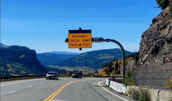
Two runaway ramps are located on the west side of Wolf Creek Pass for trucks traveling downhill and westbound. These emergency escape ramps are located on the right side of the road and preceded by warning signs at each location. Both are incline ramps.
- Runaway Ramp, MP 162.5 – approximately 4.5 miles from the pass summit
- Runaway Ramp, MP 161 – approximately 6 miles from the pass summit. This location is a trucker’s last chance to make a decision to use the ramp
If drivers are forced to use a runaway ramp:
- Maneuver the trucks into the far-right lane before approaching upgrade ramps
- As the truck approaches the runaway ramp, steer straight and try to keep the wheels aligned
- Ramps are narrow. Attempt to stay in the center of the ramp to avoid any risk of rolling over
- Once the truck is stopped, call 911 to report the incident, even if there are no injuries associated with the episode
Never Hesitate
“If a truck driver has lost control, there should never be hesitation to use the runaway ramps,” Capt. Trentini stated. “If a truck’s brakes fail due to overheating or excessive use going downhill, runaway ramps are the only way the truck will be able to stop."
Truckers should also consider the load they are hauling. The goods carried on the trucks and in the trailers are essentially the drivers’ income; there should be great concern protecting that commodity. Trentini concluded, "There may be monetary consequences for using a runaway ramp -- potential fees associated with a tow company's removal of the truck from the ramp or perhaps even a law enforcement fine. But not using the ramp can result in the ultimate cost: the irreplaceable life of a driver or the lives of those they share the road with.”
While runaway ramps are available for emergencies of out-of-control trucks, the important thing to remember is: It is imperative to maintain control of the vehicle so drivers do not need to resort to using these ramps.
Know Before You Go
Travelers are urged to “know before you go.” Gather information about weather forecasts and anticipated travel impacts and current road conditions prior to hitting the road. CDOT resources include:
- Road conditions and travel information: COtrip.org
- Download the COtrip Planner app: bit.ly/COtripapp
- Sign up for project or travel alerts: bit.ly/COnewsalerts
- See scheduled construction lane closures: bit.ly/laneclosures
- Connect with @ColoradoDOT on social media: Twitter, Facebook, Instagram and YouTube
Remember: Slow For The Cone Zone
The following tips are to help you stay safe while traveling through maintenance and construction work zones.
- Do not speed in work zones. Obey the posted speed limits.
- Stay Alert! Expect the unexpected.
- Watch for workers. Drive with caution.
- Don't change lanes unnecessarily.
- Avoid using mobile devices such as phones while driving in work zones.
- Turn on headlights so that workers and other drivers can see you.
- Be especially alert at night while driving in work zones.
- Expect delays, especially during peak travel times.
- Allow ample space between you and the car in front of you.
- Anticipate lane shifts and merge when directed to do so.
- Be patient!
Download the COtrip App!
The new free COtrip Planner mobile app was designed to meet the growing trend of information on mobile and tablet devices for the traveling public. The COtrip Planner app provides statewide, real-time traffic information, and works on mobile devices that operate on the iOS and Android platforms. Visit the Google Play Store (Android devices) or the Apple Store (iOS devices) to download!